
Keyword
Coastal management and maritime issues
10 record(s)
Type of resources
Available actions
Topics
Keywords
Contact for the resource
Provided by
Years
Formats
Representation types
Update frequencies
Status
Scale
panaceaKeywords
GEMET keywords
-
.PNG)
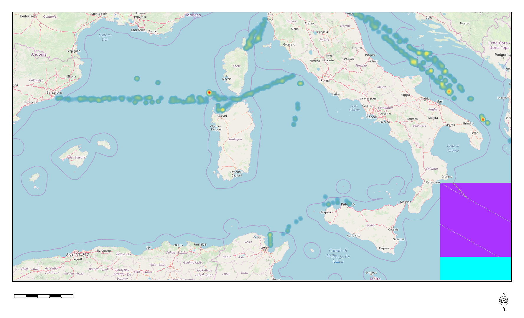
Transborder Fix line transect are used to assess amount, composition, and spatial distribution of floating macro litter, bigger than 20 cm, along fixed trans-border transects in the Mediterranean basin. The transects, monitored all year round, cross the south east partof Ligurian Sea, Sardinian Balearic basin, Bonifacio Strait, Central Tyrrhenian Sea, Sicilian Sardinian Channels, Adriatic Sea , and Ionian Sea. The surveyed area en-compasses a large portion of the Mediterranean Sea and falls withinthree MSFD marine subregions: the Western Mediterranean Sea, theAdriatic Sea, the Ionian and Central Mediterranean Sea.
-
.PNG)
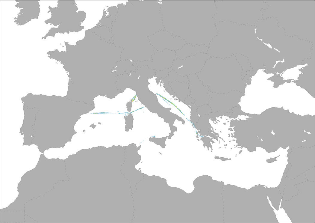
Transborder Fix line transects are used by the MedSeaLitter project to assess the amount, composition, and spatial distribution of floating macro litter, bigger than 20 cm, in the Mediterranean basin. The transects, monitored all year round, cross the south east part of the Ligurian Sea, Sardinian Balearic basin, Bonifacio Strait, Central Tyrrhenian Sea, Sicilian Sardinian Channels, Adriatic Sea, and Ionian Sea. The surveyed area en-compasses a large portion of the Mediterranean Sea and falls within the Marine Strategy Framework Directive (MSFD) marine sub-regions: the Western Mediterranean Sea, the Adriatic Sea, the Ionian and Central Mediterranean Sea.
-
.PNG)
Transborder Fix line transect are used to assess amount, composition, and spatial distribution of floating macro litter, bigger than 20 cm, along fixed trans-border transects in the Mediterranean basin. The transects, monitored all year round, cross the south east partof Ligurian Sea, Sardinian Balearic basin, Bonifacio Strait, Central Tyrrhenian Sea, Sicilian Sardinian Channels, Adriatic Sea , and Ionian Sea. The surveyed area en-compasses a large portion of the Mediterranean Sea and falls withinthree MSFD marine subregions: the Western Mediterranean Sea, theAdriatic Sea, the Ionian and Central Mediterranean Sea.
-
.PNG)
Transborder Fix line transects are used by the MedSeaLitter project to assess the amount, composition, and spatial distribution of floating macro litter, bigger than 20 cm, in the Mediterranean basin. The transects, monitored all year round, cross the south east part of the Ligurian Sea, Sardinian Balearic basin, Bonifacio Strait, Central Tyrrhenian Sea, Sicilian Sardinian Channels, Adriatic Sea, and Ionian Sea. The surveyed area en-compasses a large portion of the Mediterranean Sea and falls within the MSFD marine sub-regions: the Western Mediterranean Sea, the Adriatic Sea, the Ionian and Central Mediterranean Sea.
-
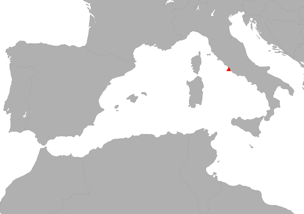
Rivers acts as a pathway for mismanaged waste to reach the sea. Results of the monitoring in the Fiumicino canal (Tiber river-Italy), estimated that 85.4 (± 9.4) litter items get into the sea each hour, with approximately 30% of which were already fragmented. Within the Medsealitter project, a surface density at the river mouth of approximately 1,270 litter items >2.5 cm and 190 litter items >20 cm per km2 was extrapolated. The percentage of the materials found is the following: Artificial polymer materials 82%; Cloth/Textiles 1%; Metal 3%; Paper/Cardboard 8%; Processed/worked wood 1%; Rubber 5%. Study reference: "Down to the river: amount, composition, and economic sector of litter entering the marine compartment, through the Tiber river in the Western Mediterranean Sea." (DOI: 10.1007/s12210-018-0747-y). Rendiconti Lincei. Scienze Fisiche e Naturali
-
The Pan-Mediterranean wetland knowledge base builds on methods and approaches developed in the framework of on-going efforts at the Mediterranean scale to map wetland ecosystems and assess their condition. It is relevant for several on-going initiatives at a regional, European and global level (e.g. UN Decade on Ecosystem restoration, EU Biodiversity Strategy for 2030, the Barcelona Convention and its protocols on Integrated Coastal Zone Management and Specially Protected Areas). As part of these efforts, ETC-UMA produced an assessment that targets the distribution, state and trends of pressures and impacts on key animal and plant biodiversity hosted by wetland habitats in the Mediterranean region. The assessment of wetland biodiversity conditions aims to complement existing knowledge and address the lack of readily available spatially-explicit information on the areas where biodiversity unique to the Mediterranean occurs, and where endemic biodiversity is most threatened, using data from The Red List of Threatened Species™ of the International Union for Conservation of Nature (IUCN). For the threatened species analysis, only species categorised in the IUCN Red List as Critically Endangered (CR), Endangered (EN) and Vulnerable (VU) were considered. The goal is to highlight priority areas for potential conservation actions in the region, and to support the regional efforts in advocating for effective wetland management and nature-based solutions in the Mediterranean region.
-
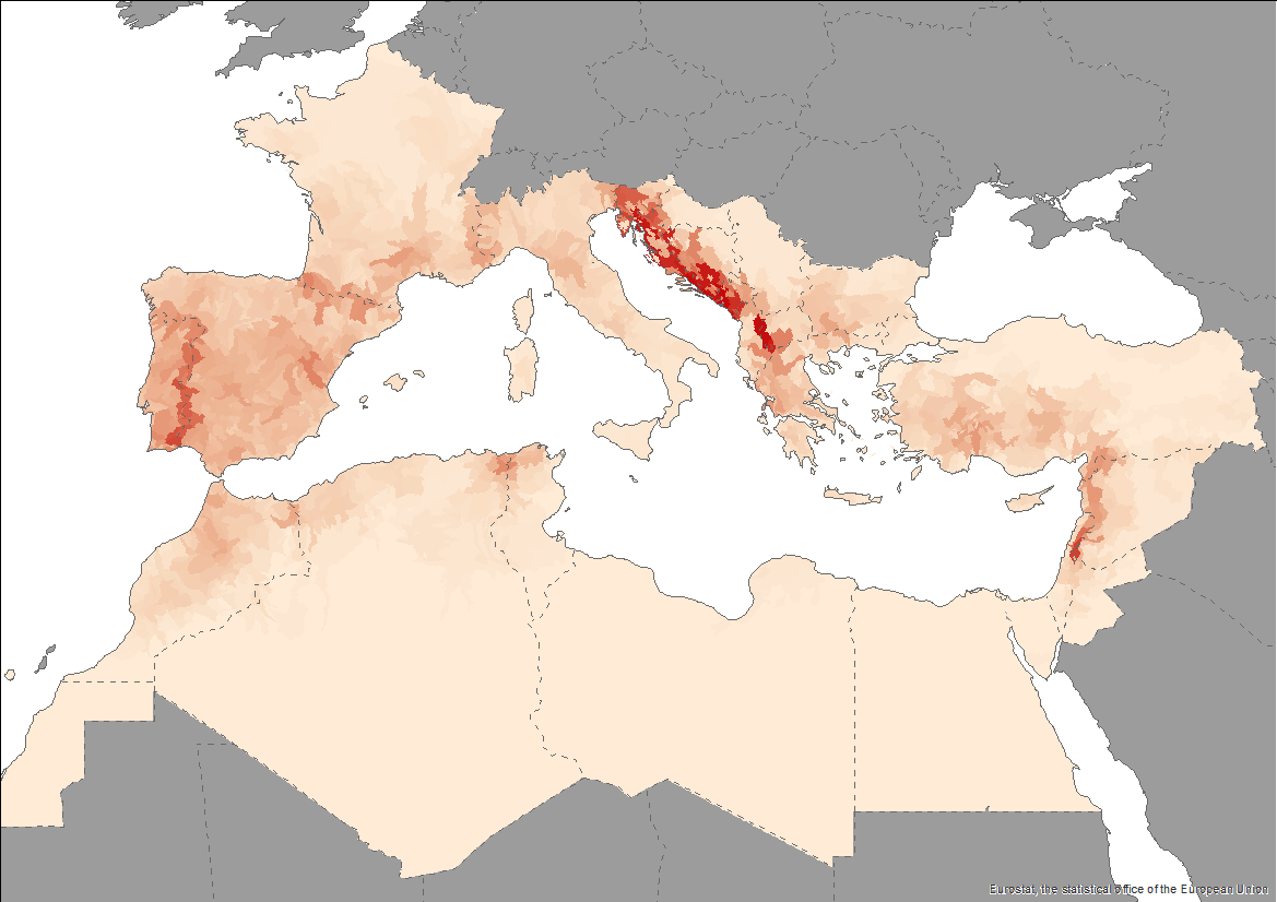
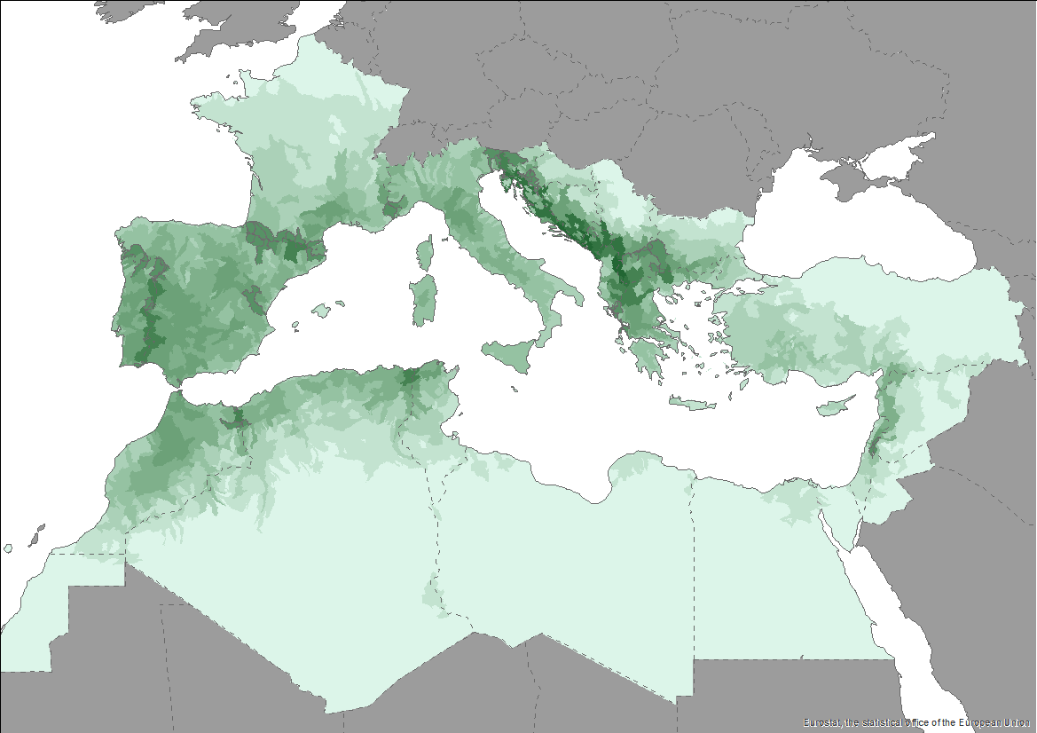
The Pan-Mediterranean wetland knowledge base builds on methods and approaches developed in the framework of on-going efforts at the Mediterranean scale to map wetland ecosystems and assess their condition. It is relevant for several on-going initiatives at a regional, European and global level (e.g. UN Decade on Ecosystem restoration, EU Biodiversity Strategy for 2030, the Barcelona Convention and its protocols on Integrated Coastal Zone Management and Specially Protected Areas). As part of these efforts, ETC-UMA produced an assessment that targets the distribution, state and trends of pressures and impacts on key animal and plant biodiversity hosted by wetland habitats in the Mediterranean region. The assessment of wetland biodiversity conditions aims to complement existing knowledge and address the lack of readily available spatially-explicit information on the areas where biodiversity unique to the Mediterranean occurs, and where endemic biodiversity is most threatened, using data from The Red List of Threatened Species™ of the International Union for Conservation of Nature (IUCN). For the threatened species analysis, only species categorised in the IUCN Red List as Critically Endangered (CR), Endangered (EN) and Vulnerable (VU) were considered. The goal is to highlight priority areas for potential conservation actions in the region, and to support the regional efforts in advocating for effective wetland management and nature-based solutions in the Mediterranean region.